Photo Links

West Dodge Aerial Photos

Photo Home | Map & List with Sm Photos | All Thumbnails
Downtown | South & Central Omaha | Universities | West Dodge | Lake & Parks

Westroad
Old Mill
Boys Town #1
Boys Town #2
Boys Town Farm
Mega-Churches

Westroads / Regency Area
Looking North

Photo is Clickable  

This photo taken by Scott Issacon between 2 pm & 3 pm on October 10, 1998

USCS 1999 Satellite Photo
 of "Westroad Area" by MSN TerraServer

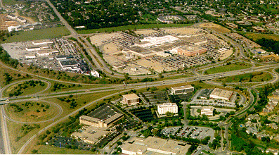
Interstate 680 - Left edge of photo.
I-680 Interchange - Lower left.
  Under reconstruction now

102nd Street - Left of Westroad.
98th Street - Right of Westroad.

Dodge St. - In middle from left to right.
Regency Parkway - Curved street
 on right, below Dodge Street.
Regency Circle - Curved horizon
street below Dodge.


Westroads  - Above Dodge Street

Regency Office Park - Below Dodge Street

is Link to photo by The Omaha Page


Photo Above

| Welcome | Links | Maps | Aerial Photos |


Send your comments, suggestions or broken link reports to:
sadams@Novia.net

The Aerial Photos background was drawn by Steve Adams.
Last Update on February 12, 2004  at 16:00 UTC (10:00 am CST)