Photo Links

West Dodge Aerial Photos

Photo Home | Map & List with Sm Photos | All Thumbnails
Downtown | South & Central Omaha | Universities | West Dodge | Lake & Parks

Westroad
Old Mill
Boys Town #1
Boys Town #2
Boys Town Farm
Mega-Churches

Boys Town #1
Looking West - Southwest

Photo is Clickable

This photo taken by Steve Adams on mid-afternoon of
Thursday September 10, 1992

USCS 1999 Satellite Photo
 of "Boys Town" by MSN TerraServer

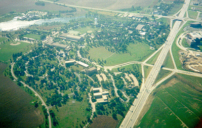
Dodge Street - The "freeway" on right side of the photo.
144th street - Run across top of the photo.

First National Business Park
 - Right of Dodge St. between interchanges.
Site of Commercial Federal Bank Headquarter Campus
 - Right of Dodge St. below lower interchange.
 

Boys Town (Tour) - Left of Dodge Street.
For information on Building listed below,
Click
on that building on the official Boy Towns tour map.

  • Information on Home Campus (picture above) and
      other US locations.

  • Boys Town Farm - Upper right corner, left of Dodge street.

  • Boys Town Center - On the far side of lake.
  • Boy Town Pylon (vertical sign) - Near "circle drive" near bottom.
  • Fieldhouse - Horizontal building in upper left center of photo.
  • Hall of History** - "white spot" left of Dodge, between the interchanges.
  • High School - Up side down "v" in center of photo.
  • Great hall - Just above left side of High School.
  • Music Hall - Right of the High School.
  • Visitor Center** / Leon Myers Stamp Center
    - Below lower interchange.
  • Youth Homes - Along the tree lined streets below 144th & lower left.

**See bottom half  of Boys town "home Campus" page for information.

See  Boys Town Tour Page for list of all building at Boys town


Photo Above

| Welcome | Links | Maps | Aerial Photos |


Send your comments, suggestions or broken link reports to:
sadams@Novia.net

The Aerial Photos background was drawn by Steve Adams.
Last Update on February 12, 2004  at 15:50 UTC (9:50 am CST)