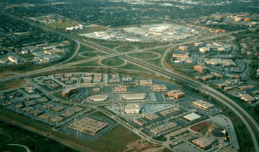
Photo Links

West Dodge Aerial Photos

Photo Home | Map & List with Sm Photos | All Thumbnails
Downtown | South & Central Omaha | Universities | West Dodge | Lake & Parks

Westroad
Old Mill
Boys Town #1
Boys Town #2
Boys Town Farm
Mega-Churches

Old Mill Area
Looking Northeast

Photo is Clickable

This photo taken by Steve Adams on mid-afternoon of 
Thursday
September 10, 1992

USCS 1999 Satellite Photo
 of "Boys Town Farm" by MSN TerraServer

Dodge Street - Left center to upper right
Interstate-680 - Upper left to lower right
108th Avenue - Below Interstate-680,
Left center to bottom center.

I-680 Interchange: Upper Center
Regency Parkway: Curved Street
on the left, between Dodge St &
Interstate-680


Westroad Mall
- Area - Above the Interchange
Regency Office Park - Right of the Interchange
Old Mill Office Park - Below the Interchange


Below 108th Ave.
In the "Stonebreak Office Park"
- Group of small buildings above lower left.

  • ACI* - Applied Communication Inc
  • TSA -Transaction System Architects

ACI* Headquarter Building
- Sq. building right of the Stonebreak Office Park

Above 108th Ave. - on Farman Dr.
- Farman Dr. - 2nd horizon street below
   the Interchange

*an  TSA Companies

Christ Community
Church

Below & lower right of 
photo above.

Looking East - Southeast

by Steve Adams - Oct 10, 1998


Photo Above

| Welcome | Links | Maps | Aerial Photos |


Send your comments, suggestions or broken link reports to:
sadams@Novia.net

The Aerial Photos background was drawn by Steve Adams.
Last Update on February 12, 2004  at 16:00 UTC (10:00 am CST)