|
  Boys
Town (Tour) - Below Dodge Street
Boys
Town (Tour) - Below Dodge Street
For information on Building listed
below,
Click
 on that building on the
official Boy Towns tour map.
on that building on the
official Boy Towns tour map.
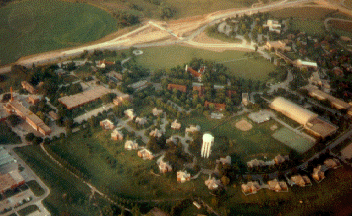
- Information on
Home Campus (picture above)
and
other
US locations.
-
Alumni
Veterans Memorial - Small
circle above the fieldhouse.
- Boy
Town Pylon (vertical sign)
-
Chambers
Protestant Chapel** - Below
left end of the interchange.
- Dowd
Memorial Chapel / Father Flanagan
Shrine**
- Below the heart of
the Interchange or boy town entry road.
-
Father
Flanagan House / Rose Garden**
- Left of Chamber Chapel.
- Fieldhouse
- The Lange white roof building center right of
Photo.
- Hall
of History** - Between Chamber
Chapel & Dowd Chapel
-
High
School - Horizontal building
on right.
- Music
Hall - Above & left of
High School.
- Youth
Homes - Along street at
bottom of the photo.
**See bottom half of Boys town "home
Campus" page for information.
See Boys Town Tour Page for list of all building at Boys town
|