Photo Links

Lakes & Parks Aerial Photos

Photo Home | Map & List with Sm Photos | All Thumbnails
Downtown | South & Central Omaha | Universities | West Dodge | Lake & Parks

Standing Bear Lake
Ed Zorinsky Lake
Wehrspann Lake

Mahoney Park #1
Mahoney Park #2

Ed Zorinsky Lake
Looking West-Northwest


This photo taken by Steve Adams between 2pm& 3pm on October 10, 1998
USCS 1999 Satellite Photo
 of "Mega-Church" by MSN TerraServer

156 Street - Goes across the dam.
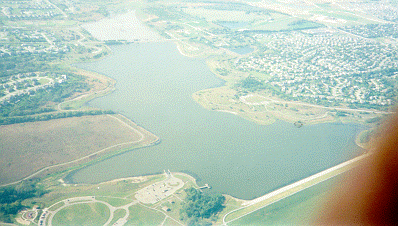
Ed Zorinsky Lake - For Location see "Papio Lakes page"
a Papio-Missouri River Natural Resources District - Flood Control Reservoirs

The Recreation Area has

  • 7  miles of trails for biking, hiking & jogging
  • Fishing, boating
  • Picnic Areas & playgrounds
  • Sport fields (football, Soccer, softball)

A hike / bike trails system, The Papio Trails [map], will connect
Omaha area parks and Papio lakes. Another Trails map
 from UNOmaha Map
 

Photo Above

| Welcome | Links | Maps | Aerial Photos |


Send your comments, suggestions or broken link reports to:
sadams@Novia.net

The Aerial Photos background was drawn by Steve Adams.
Last Update on February 12, 2004  at 16:00 UTC (10:00 am CST)