Photo Links

Downtown Aerial Photos

Photo Home | Map & List with Sm Photos | All Thumbnails
Downtown | South & Central Omaha | Universities | West Dodge | Lake & Parks


Two Casinos
The Old Market
Downtown #1
Downtown #2
Downtown #3
Major Buildings

Jim
Burnet's
Downtown #3
Looking South - Southeast

Photo is clickable

This photo taken by Scott Issacon between 2 pm & 3 pm on October 10, 1998

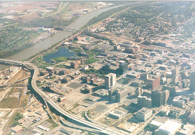
USCS 1999 Satellite Photo
 of "Downtown #3" by TerraServer

Downtown Omaha, Inc. (DOI) has downtown community/business links 
Intersate I-480 - The bridge from center left side to bottom center of photo
Missouri River - Center left to top center of photo

* Subpage of Douglas County Environmental Services website

is Link to photo by Aim Photo Link
is Link to photo by The Omaha Page


Photo Above

| Welcome | Links | Maps | Aerial Photos |


Send your comments, suggestions or broken link reports to:
sadams@Novia.net

The Aerial Photos background was drawn by Steve Adams.
Last Update on May 26 , 2005 at 20:15 UTC (3:15pm  CDT)