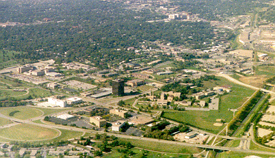
Photo Links

Central Omaha Aerial Photos

Photo Home | Map & List with Sm Photos | All Thumbnails
Downtown | South & Central Omaha | Universities | West Dodge | Lake & Parks

Ak-Sar-Ben
72nd & Center
84th & Center

72nd & Center Area
looking Northwest

Photo is Clickable

This photo taken by Scott Issacon between 2 pm & 3 pm on October 10, 1998

USCS 1999 Satellite Photo
 of 72nd and Center Area by MSN TerraServer

West Center Road - Run across the bottom of photo
Mercy Road - From Center left to lower right
Pine Street - Short horizontal short at center right
72nd Street -Angle from lower left to upper right
Little Papilion Creek - Runs vertically at lower right

** Part of Nebraska Methodist Heath Care System
*** Part of
Children's Heathcare Services


Photo Above

| Welcome | Links | Maps | Aerial Photos |


Send your comments, suggestions or broken link reports to:
sadams@Novia.net

The Aerial Photos background was drawn by Steve Adams.
Last Update on February 12, 2004  at 15:50 UTC (9:50 am CST)